
 |
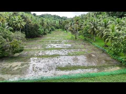
| Oikos Peace Garden in Bilar, Bohol is a permaculture project that practices organic and bio-dynamic farming methods. Aerial photo taken at an altitude of 24 meters by Tello drone. |
Permaculture design is about individual action and making positive change in the landscape. And what better way to see our impact than from the sky!
We're advocating the use of aerial photography for documenting how common people are influencing their landscapes with permaculture. A single aerial photo speaks volumes. It can inspire you and at the same time makes you aware of your surrounding environment from a view that we only get to see either from a plane or a tall building.
"How do I influence my landscape?" was a question that popped up while scanning through several aerial photos we took with our Ryze (DJI) Tello drone--a budget UAV that we have been using for research since last year. It's a cheap drone ($99.00) with a 5 MP camera. But don't let the specs fool you! When used for a good purpose, there are many opportunities and applications for the Tello. T3.com even awarded it as the top budget drone for 2019.
Our Instagram account is currently focused on answering the question "How do I influence my landscape?" So we are encouraging people to share their photos and their stories with us on social media by using the hashtags #MyLandscape and #PermaGardenPH.
Aside from documenting landscapes with a permaculture design, some delegates from the recently concluded 3rd Philippine Permaculture Convergence had some ideas for the drone:
1) Citizen science - the general public can provide real-time visual data to scientists and researchers
2) Environment - documentation of land use and land cover change; detection of polluted areas in coastlines, forests, and other ecosystems; detection of illegal activities such as backyard burning
3) Agriculture - crop and livestock monitoring; farm management
4) Biodiversity Conservation - surveillance of protected areas; monitoring of reforestation projects
5) Disaster Risk Reduction and Management - reconnaissance and aerial survey; search and rescue
and of course,
6) Environmental communication - aerial photos can be used for info dissemination campaigns and public education regarding environmental and climate issues. Students can use the drone for research projects, posters, and presentations.
 |
| This aerial photo of a group of people in a forest gave us the idea that Tello can be used to report illegal logging or poaching activities in the forest. The small drone is relatively quiet and can be a useful tool for park rangers. |
 |
| Using a 3D-printed mirror clip attachment from PHTek, the Tello can take downward view aerial photos. |
While high-end drones with better cameras are available in the market, the price, size, portability, durability, and usability of the Tello sets it apart from other commercial drones. Well, at least until DJI/Ryze releases a new version of the Tello.
You can purchase the Tello at any DJI outlet or you can order it at the DJI store. The drone is also available on Lazada.


No comments:
Post a Comment